Collecting speed and travel time data without using roadside infrastructure could offer new possibilities to cash-strapped road authorities. Streaming video may be useful for traffic controllers to monitor incidents and automatic number plate recognition may be required for enforcement, but neither are necessary for many ITS functions. For instance travel times, tailbacks, percentage of vehicles turning, origin and destination analysis can all be done using Bluetooth and/or WI-Fi sensors and without video o

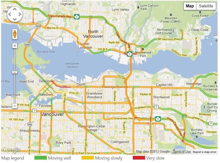
Vancouver travel map showing congestion derived from the
IBI Cellint data
Collecting speed and travel time data without using roadside infrastructure could offer new possibilities to cash-strapped road authorities.
Streaming video may be useful for traffic controllers to monitor incidents and automatic number plate recognition may be required for enforcement, but neither are necessary for many ITS functions. For instance travel times, tailbacks, percentage of vehicles turning, origin and destination analysis can all be done using Bluetooth and/or WI-Fi sensors and without video or ANPR (ITS International September/October 2013). However, these systems require roadside deployment and only detect vehicles in the immediate vicinity.
Those opting for non-visual systems may also consider other ways of monitoring the movement of mobile phones such as the technology being marketed by Israel-based5898 Cellint Traffic Solutions. Its TrafficSense technology utilises the cellular systems of the mobile carriers to anonymously monitor the movements of mobile phones when they are communicating with the network on the control channel. These are then positioned by comparing the live network information with a predetermined cellular map of the route.
Ofer Avni, CEO at Cellint says: “We don’t need to install roadside equipment as all our data gathering is done at the main switching centres of the mobile network Provider. For instance in many European countries it means connecting to less than 30 points in the network although it does require one operator with at least 15% penetration.”
Cellular network providers have a number of transmitters/receivers to cover any part of the network in each town and city as well as along major transport routes. Since data for accurate triangulation of the signal from several transmitters is not available at the switching centres and is not accurate in urban environment, Cellint maps the cellular network on the road. This creates a reference database allowing the exact location of a device to be determined in complete certainty every 250 metres on average in urban areas.
In order to map the cellular network in the areas of interest and improve accuracy, an instrumented vehicle will be driven along all routes of interest to the road authority and its position logged against the readout from the cellular providers control channel messages.
GPS coordinates are then assigned to each anonymous data sample collected from the network and then compared with the signalling maps prepared in advance. By comparing the live results with those from the test drive, the company says a phone’s location can be pinpointed to within a few tens of metres, travel speeds calculated within 8km/h (5mph). And because latency is very low, delays can be detected within a few minutes (similar to road sensors).
“Bluetooth and Wi-Fi based detection systems used by others for monitoring the roads require the installation of roadside equipment – ours does not,” says Avni. “This also makes it very quick and easy to set up temporary monitoring – for example at roadworks. We only need to send the test car along to create a cellular map of that part of the route – everything else is in place. So, in effect, anything you can do with Bluetooth and Wi-Fi monitoring, you can do with Cellint at a lower cost and much higher granularity.”
As a result he says a road can be monitored using Cellint’s system at a fraction of the cost of systems requiring roadside installations and the bigger and more complex the monitored area becomes, the bigger the savings. For example he says that in the recent validation in Vancouver, the data available was equivalent to that from 3,900 roadside sensors. That data is fed into IBI’s traffic management and traveller information software to inform the traffic control rooms and also to provide travel times and traveller information.
“The project has been ongoing for more than a year and covers 2,000km in British Columbia. The authorities in Vancouver checked the results from the combined Cellint/IBI system with those from several types of sensors, including inductive loops and Bluetooth. The results showed an excellent match in detecting speed changes, speed over short segments and travel time between junctions,” says Avni.
Due to its positioning technology, TrafficSense is equally at home in the city where it can be used to monitor time delays and tailbacks at intersections and the proportion of vehicles turning left or right as well origin/destination data gathering.
As their movement behaviour is different, statistical methods can be applied to monitor cyclists/pedestrians and bus passengers (ie frequent stops) which can be isolated or excluded from the data if required.
The urban environment is also an area of differentiation between Cellint and GNSS monitoring as Avni explains: “Since this technology uses cellular discrepancies as data points along the road, urban canyons which can disrupt satellite signals provide TrafficSense with higher resolution and more accuracy. It is also completely anonymous as the telephone number of the device is not captured, stored or transmitted so there are no problems with privacy issues. In addition, the system reports only statistical information which includes many data points from many phones, aggregated over time.”
As with Bluetooth/Wi-Fi monitoring, Cellint’s system is not affected by weather or lighting conditions and it cannot provide definitive traffic numbers or divide vehicles into specific lanes (such as high occupancy) in the same way as ANPR or visual systems. However, Avni says dealing with real-time congestion is about time delays to motorists and not the numerical number of vehicles and that historical volumes (by day of the week or time of day) can be analysed and traffic volumes calculated for road planning with 95% accuracy.
As to the differentiation in high occupancy lanes, this can be done in real time if the HOV lane separates from the main highway in some sections or has a separate on- or off-ramp. Alternatively micro analysis can be done to determine vehicle speeds on the main highway and in the HOV lanes.
Another potential weakness is late at night when the sample size can drop thereby reducing the accuracy of readings or even delaying the detection of incidents.
Avni says only 1% of congestion happens at that time and it is usually as a result of planned construction works or similar and that when there is very little traffic on the road, there can also be long delays in sensors detecting an incident – sometimes up to an hour.
Flow data is processed by the system and can be combined with information from other sources, such as police reports for the cause of the problem, and sent via web interface or direct connection to the traffic authority’s traffic control centre’s servers.
“Our output can be used in any way the authority wishes: reports by exception for incident detection to patrol cars; real-time/planning optimisation of signal timings; feeding travel times or congestion warnings to variable message signs; displayed on a website or on smartphones via an app.
“Depending on what the authority requires all of this can be done automatically so there are no field labour costs or a need for roadside equipment. The system can be installed very quickly and the cost of installation and maintenance is an order of magnitude lower than with the alternatives.”
Streaming video may be useful for traffic controllers to monitor incidents and automatic number plate recognition may be required for enforcement, but neither are necessary for many ITS functions. For instance travel times, tailbacks, percentage of vehicles turning, origin and destination analysis can all be done using Bluetooth and/or WI-Fi sensors and without video or ANPR (ITS International September/October 2013). However, these systems require roadside deployment and only detect vehicles in the immediate vicinity.
Those opting for non-visual systems may also consider other ways of monitoring the movement of mobile phones such as the technology being marketed by Israel-based
Ofer Avni, CEO at Cellint says: “We don’t need to install roadside equipment as all our data gathering is done at the main switching centres of the mobile network Provider. For instance in many European countries it means connecting to less than 30 points in the network although it does require one operator with at least 15% penetration.”
Cellular network providers have a number of transmitters/receivers to cover any part of the network in each town and city as well as along major transport routes. Since data for accurate triangulation of the signal from several transmitters is not available at the switching centres and is not accurate in urban environment, Cellint maps the cellular network on the road. This creates a reference database allowing the exact location of a device to be determined in complete certainty every 250 metres on average in urban areas.
In order to map the cellular network in the areas of interest and improve accuracy, an instrumented vehicle will be driven along all routes of interest to the road authority and its position logged against the readout from the cellular providers control channel messages.
GPS coordinates are then assigned to each anonymous data sample collected from the network and then compared with the signalling maps prepared in advance. By comparing the live results with those from the test drive, the company says a phone’s location can be pinpointed to within a few tens of metres, travel speeds calculated within 8km/h (5mph). And because latency is very low, delays can be detected within a few minutes (similar to road sensors).
“Bluetooth and Wi-Fi based detection systems used by others for monitoring the roads require the installation of roadside equipment – ours does not,” says Avni. “This also makes it very quick and easy to set up temporary monitoring – for example at roadworks. We only need to send the test car along to create a cellular map of that part of the route – everything else is in place. So, in effect, anything you can do with Bluetooth and Wi-Fi monitoring, you can do with Cellint at a lower cost and much higher granularity.”
As a result he says a road can be monitored using Cellint’s system at a fraction of the cost of systems requiring roadside installations and the bigger and more complex the monitored area becomes, the bigger the savings. For example he says that in the recent validation in Vancouver, the data available was equivalent to that from 3,900 roadside sensors. That data is fed into IBI’s traffic management and traveller information software to inform the traffic control rooms and also to provide travel times and traveller information.
“The project has been ongoing for more than a year and covers 2,000km in British Columbia. The authorities in Vancouver checked the results from the combined Cellint/IBI system with those from several types of sensors, including inductive loops and Bluetooth. The results showed an excellent match in detecting speed changes, speed over short segments and travel time between junctions,” says Avni.
Due to its positioning technology, TrafficSense is equally at home in the city where it can be used to monitor time delays and tailbacks at intersections and the proportion of vehicles turning left or right as well origin/destination data gathering.
As their movement behaviour is different, statistical methods can be applied to monitor cyclists/pedestrians and bus passengers (ie frequent stops) which can be isolated or excluded from the data if required.
The urban environment is also an area of differentiation between Cellint and GNSS monitoring as Avni explains: “Since this technology uses cellular discrepancies as data points along the road, urban canyons which can disrupt satellite signals provide TrafficSense with higher resolution and more accuracy. It is also completely anonymous as the telephone number of the device is not captured, stored or transmitted so there are no problems with privacy issues. In addition, the system reports only statistical information which includes many data points from many phones, aggregated over time.”
As with Bluetooth/Wi-Fi monitoring, Cellint’s system is not affected by weather or lighting conditions and it cannot provide definitive traffic numbers or divide vehicles into specific lanes (such as high occupancy) in the same way as ANPR or visual systems. However, Avni says dealing with real-time congestion is about time delays to motorists and not the numerical number of vehicles and that historical volumes (by day of the week or time of day) can be analysed and traffic volumes calculated for road planning with 95% accuracy.
As to the differentiation in high occupancy lanes, this can be done in real time if the HOV lane separates from the main highway in some sections or has a separate on- or off-ramp. Alternatively micro analysis can be done to determine vehicle speeds on the main highway and in the HOV lanes.
Another potential weakness is late at night when the sample size can drop thereby reducing the accuracy of readings or even delaying the detection of incidents.
Avni says only 1% of congestion happens at that time and it is usually as a result of planned construction works or similar and that when there is very little traffic on the road, there can also be long delays in sensors detecting an incident – sometimes up to an hour.
Flow data is processed by the system and can be combined with information from other sources, such as police reports for the cause of the problem, and sent via web interface or direct connection to the traffic authority’s traffic control centre’s servers.
“Our output can be used in any way the authority wishes: reports by exception for incident detection to patrol cars; real-time/planning optimisation of signal timings; feeding travel times or congestion warnings to variable message signs; displayed on a website or on smartphones via an app.
“Depending on what the authority requires all of this can be done automatically so there are no field labour costs or a need for roadside equipment. The system can be installed very quickly and the cost of installation and maintenance is an order of magnitude lower than with the alternatives.”


