Designing a future-proof roadside communications system is something all authorities would like to achieve. New Hampshire DoT believes it has come up with a solution, as Colin Sowman reports.
Someone once likened predicting the future to ‘nailing a jelly to the wall’. With ITS, C-ITS and V2X technology progressing at such a pace, predicting the future is more akin to trying to nail three jellies to the wall – but only having one nail. And yet with roadways having a lifetime measured in decades, that is exactly what highway engineers and traffic planners are expected to do. Fortunately, New Hampshire DoT (NHDoT) believes its technological advances may be able to provide a solution.
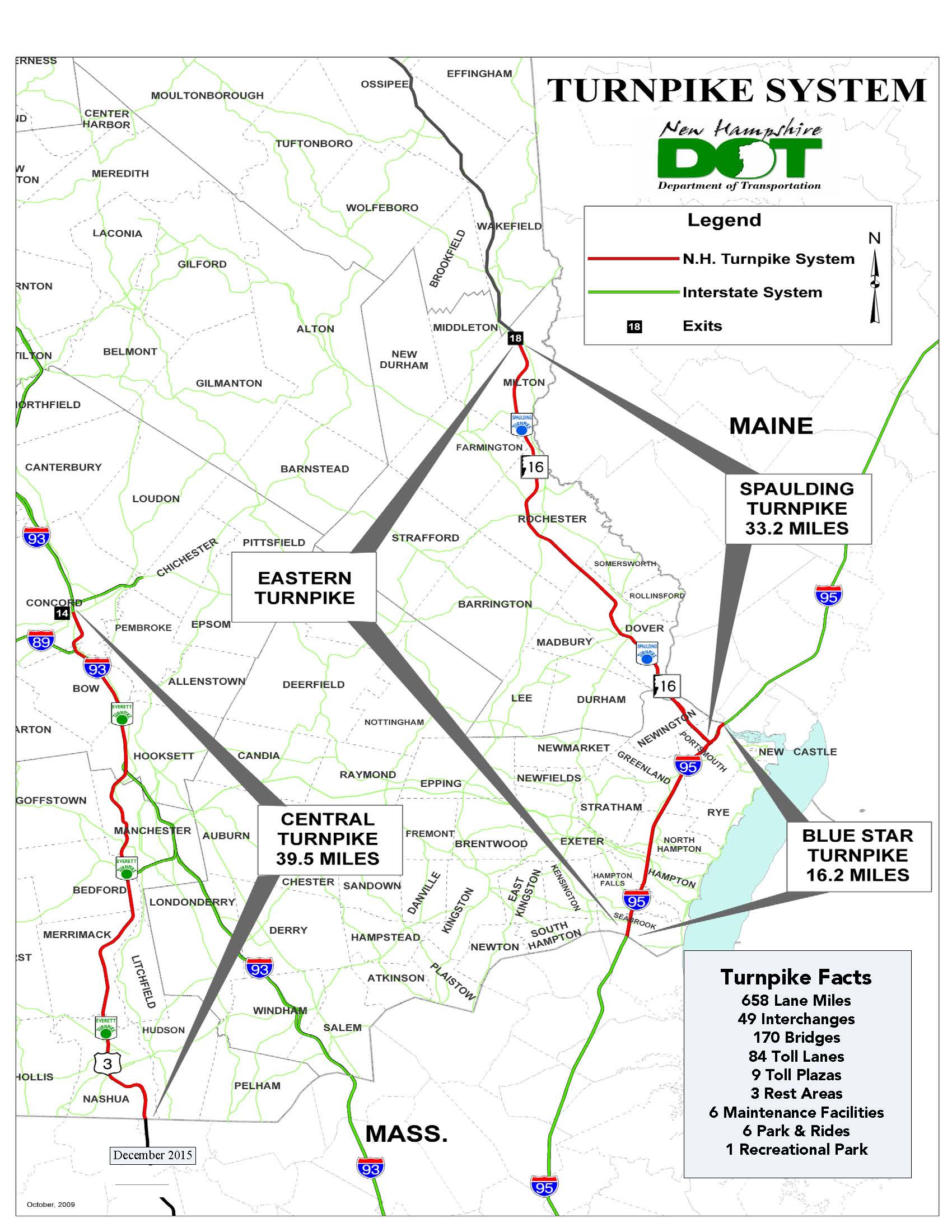
The Central New Hampshire Turnpike (or to give it its correct title, the Frederick E. Everett Turnpike), runs 71km (44 miles) northwards from Nashua on the Massachusetts border to Concord, and comprises two or three lanes in each direction. During one of its regular evaluations, NHDoT identified the corridor as having a relatively high rate of road traffic accidents and, following a full study, decided additional ITS would provide useful safety benefits ahead of a planned upgrade to widen the current two-lane sections.
Susan Klasen of NHDoT’s Traffic Systems Management and Operations department, says: “We are always looking for where we can get the ‘best bang for our bucks’ on safety and mobility and there’s a lot of traffic on that corridor and any incident causes a lot of delay, frustration and secondary crashes. And we have a lot of ITS systems we know work and where our people are familiar with their operation.
“So we drew up a basic masterplan knowing that we needed to install a communications backbone while keeping mind that other changes are coming. We never want to delay potential safety improvements so we decided to get on with installing those known ITS systems in key locations along the corridor but without limiting our options for the changes we know lie ahead.”
The Everett Turnpike joins with the I-93 (which already has a fibre optic communications backbone) for about 16km (10 miles) at the northern end of the corridor. The planned communications backbone in the un-instrumented section of the Everett Turnpike was needed to connect additional cameras, variable message signs, incident detection sensors and road weather stations in the near term. In addition, it must also be able to easily accommodate the planned road widening in certain sections and the switch to open road tolling while, at the same time, time remaining adaptable enough to meet future needs including connected and autonomous vehicles. As the requirements of vehicle-to-infrastructure communications have yet to be fully tested and finalised, and the needs of autonomous vehicles have not even been properly defined, it makes specifying the system configuration far from easy.
NHDoT has awarded a contract for the design and construction of the Everett Turnpike’s new ITS system to a design/build team led by IT and network construction company Tilson, integrated design and technology firm
Project manager Mike Costa from MobilityTech, sums up the project by saying: “This is an extension to New Hampshire’s state-wide Advanced Traffic Management System (ATMS) program that has been implemented on some other corridors. These use a combination of wired and wireless communications but what we are planning here is not only an extension of that network but is being designed to ensure we can accommodate the future technologies we know are coming. Even as we are planning this, new standards and protocols that will primarily support vehicle-to-infrastructure components are emerging. So the overall project’s design team has been keeping up with those changes to ensure the requirements are reflected in the design of the communications system.”
To accommodate both the planned roadway changes and the unknown future technology requirements, the decision was taken to adopt a microwave-based communications backbone providing bandwidth up to 1.5gb/second. The antenna locations in the network backbone are being designed to provide full ‘radio line of sight’ between adjacent transmitter/receivers that form the backbone to maximise system reliability under adverse weather conditions.
The initial configuration will see four transmitters/receiver units placed along the currently un-instrumented stretch of the turnpike, with the longest link distance being 16km (10 miles), with the others being between 4.8km and 8km (3 and 5miles). Individual ITS elements such as cameras, signs and weather stations, will be fitted with a microwave transceiver capable of speeds of more than 100mbps. The microwave transceiver at the device connects to a point-to-multipoint transceiver in the backbone. As additional services and systems are added to the roadway, the corresponding device transceivers can be connected into the communications backbone.
“The design of the microwave backbone gives us a lot of flexibility in terms of ease with inserting new equipment and its capacity does not impose onerous restrictions on the volume of data that can be transmitted,” says the project’s design and integration lead, IBI Group’s Carl-Henry Piel.
Of the roadside applications to be connected to the backbone, the highest bandwidth demand will come from streaming live video from the cameras along the route. The current design calls for 13 new CCTV cameras to be installed, with many more planned as the road reconstruction is completed. Tilson’s Mike MacCannell, who is overall principal in charge of the project, points out that system design will use the available bandwidth efficiently: “All the cameras specified on this project will be digital IP equipment and use H.264 image compression to reduce demand on the network.”
When asked about the use of in-camera processing for applications such as incident detection, Piel replies: “If bandwidth was limited we might consider that approach and install processing in a roadside cabinet with the video image processing equipment which would send an alert if a problem were detected. But we have more than enough bandwidth to stream the live feeds and do any processing and detection back at the control centre.”
To deliver the video signals to operators in the traffic management centre, New Hampshire Turnpike’s microwave communications backbone will be connected to the existing fibre optic cable installed along the I-93.
More than 12 radar-based vehicle detectors will be installed to monitor traffic flow while four existing road weather information stations, which currently operate using a cell-data network connection, will be connected to the new communications backbone. At the traffic management centre, speed and volume data from the roadside detectors are monitored, and alerts are automatically presented to control room operators if specific threshold conditions are crossed. State police officers share the control room with the traffic controllers and all pertinent information is immediately passed between the two.
Common platform
New Hampshire, Maine and Vermont share a single ‘Compass’ ATMS system which was developed in conjunction with
Once the road widening and move to Open Road Tolling (ORT) has taken place, the additional cameras and variable message signs will be installed and connected to the backbone using point-to-multipoint transceivers. Furthermore, with ample bandwidth still available and low network latency, vehicle-to-infrastructure (V2I) communications hardware installed along the roadway can be easily accommodated in the network.
In terms of costs, Costa says: “It is certainly far cheaper to use microwave technology than it would be to trench-in fibre optic cable to extend the department’s existing network the remaining 30 miles to the Massachusetts border, and the overall cost of the backbone is far lower. From a reliability viewpoint, the design includes full redundancy, meaning that between the endpoints, each link has effectively two paths for data transmission.”
Full implementation will, according to MacCannell, be around 18 months – albeit that, as it is situated in the north-east corner of the US, that timescale is weather-dependent.


