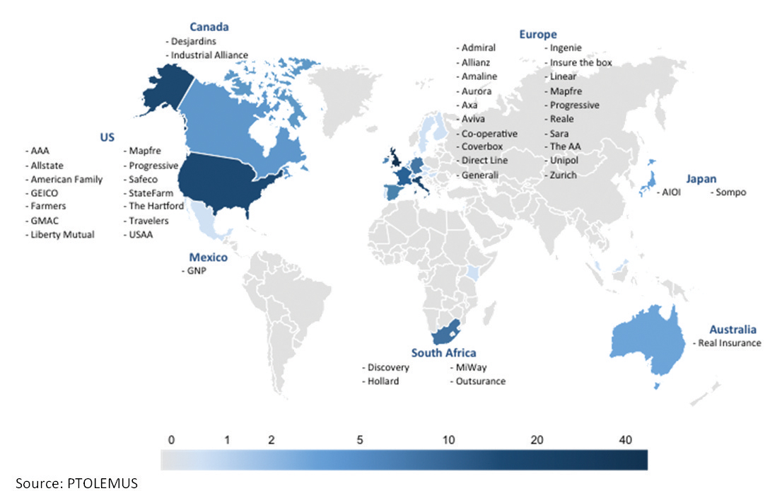
User-based insurance is blazing a trail others would like to follow and is also discovering the challenges.
The ITS sector needs to keep a very careful eye on the automotive industry: “There’s a war going on in the connected car space creating richer datasets than we ever imagined possible” says Paul Stacy, research and development director of
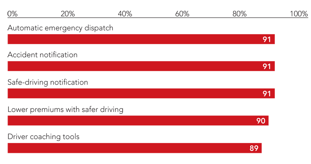
For instance, Stacy told the recent Insurance Telematics Europe 2015 conference in London, the Co-operative car insurance group “now has 84% of its policy holders logging on once a month to check their status.” People are getting more and more comfortable with using the data they generate when they drive, provided they can see the benefits to them as a consumer.
Delegates at the event, organised by
ITS Professionals
For ITS professionals, mobility will remain a key issue. Iain Macbeth, behaviour change programme manager with
London’s projected population growth “is the equivalent of putting the whole of Birmingham and Leeds inside the M25 (London’s orbital motorway) in the next 15 years,” says Macbeth. Two new cities are about to crash into in an already overcrowded urban sprawl. Make no mistake, “the big issue for us is mobility” he said. Despite the fact that London is building a new east-west Crossrail train line (currently the biggest infrastructure project in Europe) and extending its north-south Northern Line metro route, roads are - and will remain - the key battleground. London is spending more than £4billion ($6.2billion) over six years on these initiatives, and it knows there will be more to come.
“Drivers are still our biggest customer,” says Macbeth. “Cars and freight vehicles, especially light goods vehicles” dominate the transport mix. Keeping London’s traffic on the move is going to remain a top priority and the city is working on a major road reorganisation plan. TfL is also hoping that car ownership trends will see shared passenger vehicles and shared freight loads continue to grow in popularity. London has a young demographic and Macbeth can see some encouraging trends. “Young people in London are less eager to buy cars, for a variety of reasons such as problems with parking and the cost of insurance. They increasingly see mobility as a service rather than an ownership issue. There is an interesting new dynamic emerging.”
Jacques Amselem, the chief executive of telematics at
But car sharing is just one “interesting new dynamic.” What about autonomous cars? For Jacques Amselem, the issue here will be “the need to shift responsibility from the driver to the car manufacturer. It’s going to need a whole new type of insurance product,” he said, with a new approach to the impact and role of the road infrastructure itself and the car’s product liability cover. Today, the driver is always responsible for what happens on the road. The driver can cut in at any time and override the car. In the future, this will change. The driver will become a passenger. “And then it gets interesting,” says Macbeth. “What happens when there is a crash, as there’s bound to be?”
TfL is currently running a series of autonomous vehicle tests in Greenwich, south-east London. “There are going to be lots of baby steps along the way to the autonomous car,” says Macbeth. Things are not going to happen fast, but the benefits are there to be seen. “30% of London’s congestion is due to very minor collisions.” Maybe autonomous cars could stop these collisions taking place? And maybe autonomous vans and light goods vehicles could help businesses in the city cope with a chronic shortage of young commercial vehicle drivers? Perhaps this new dynamic will also encourage more and more people to think twice about making a short car journey of only 1km to 2km? Maybe not.
Mapping the future
The interactive digital map will be “the core of everything” in the future. According to Peter Beaumont, director of enterprise customer and market development at Nokia subsidiary
He told the conference, “the way we build and deliver maps will increasingly be specific to the user. We will collect data differently, looking at the way in which the map is used. HERE has taken 20 to 25 years to build the map of the world we have today.”
Around the world
Because HERE-equipped cars drive roads around the world collecting real-time data all of the time, the company can “add three million changes per day to the map databases,” says Beaumont. The system constantly logs “new speed limits at junctions, one-way street changes, road signs, traffic lights, with 80 billion probe points collected every month and traffic analysis from more than 40 counties.”
The stats are impressive: the HERE platform serves 9.1 billion transactions a week, delivers 1.7 billion map tiles,
2 billion search and geocode requests and 390 million routing instructions.
Increasingly, “maps will be used to analyse and contextualise the journey and will be able to assess the risk by different road types,” Beaumont adds. Factors like the road geometry and potential danger zones – such as schools - will all be coded in so ITS professionals will not need to assess journey risks road by road, all of the necessary data will be built into the mapping. Users will be able to get accurate routing and time of arrival information all based on real historical data. Beaumont said HERE has the industry’s largest advanced content portfolio and the core components of the platform are:
• Mapping (global coverage and satellite imagery, venue maps and map rendering);
• Directions (traffic-enabled routeing, truck, vehicle and pedestrian routeing, public transit routeing, matrix routeing, isoline routeing);
• Traffic data (traffic tiles for real time and historical flow data and traffic incidents);
• Places (POI search);
• Geocoding (global map coverage with local search, geocoding and reverse geocoding, batch geocoding);
• Platform extensions (custom location, platform data, route matching, toll costing, mobile SDK).
And, as the automotive sector builds ever more complex technologies into cars, Beaumont predicts driverless cars using high definition mapping and advanced lane guidance will be a reality by 2025. The road users of the future will be enjoying the benefits of improved:
• route tracking and display with road conditions including incident data and weather;
• multimodal route navigation;
• journey-specific places of interest, destination information and parking availability;
• emergency services, crash notification and updated information on roadside assistance;
• driving alerts and coaching aids such as speeding and upcoming hazards and eco-driving feedback.


